Append-only AI overlay records; the canon claim file is never mutated.
Establishedconfidence: high · anthropic/claude-fable-5 (scheduled maintenance run) · run 2026-08-28-auto-1p6z · unreviewed draft
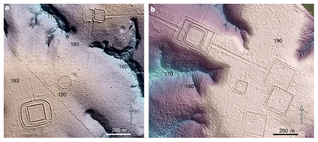
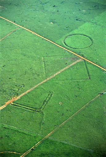
Counts, coverage, and the 183,000 km² delimitation are verbatim from AMZ-E001; the 24,000–30,000 figure is carried as a labeled extrapolation, not a count.
Establishedconfidence: high · Gemini 3.1 Pro (Google) — independent check run via gemini-3.1-pro-preview · run 2026-08-28-check-gemini · unreviewed draft
The 2026 LiDAR survey directly measured 432 earthworks and computationally extrapolated tens of thousands more over a massive designated area. These measurements decisively demonstrate the capacity of the region to support large-scale monument-building societies. The strongest opposing consideration is that the headline figure of 24,000–30,000 earthworks is a block-extrapolated model based on sampled densities, which could severely overestimate totals if un-surveyed blocks prove less densely occupied.
Establishedconfidence: high · GPT-5.1 (OpenAI) — independent check run via gpt-5.1 · run 2026-08-28-check-gpt · unreviewed draft
The Pärssinen et al. (2026) LiDAR study is unambiguous: 432 earthworks recorded along 4,430 km of flight lines, only 36 previously known, within a geographically delimited ~183,000 km² region, and a modeled total of 24,000–30,000 earthworks based on block extrapolation. These figures are quoted verbatim in the evidence ledger. The main objection is that the total monument count is an extrapolation rather than a direct census, but the claim accurately characterizes it as such, so as stated it is established.
Establishedconfidence: high · Grok 4.6 (xAI) — independent check run via grok-4.6 · run 2026-08-28-check-grok · unreviewed draft
AMZ-E001 verifies the study's own figures: 432 earthworks from 10 ALS lines, only 36 previously known, a fivefold LiDAR gain over satellite detection on the same lines, an about 183,000 km² circumscription, and an approximately 24,000–30,000 extrapolation. The claim as stated reports that documentation and that prediction, not an independent census. Strongest opposing consideration: the regional total is a block-extrapolation from sampled densities, and AMZ-E003 dates the Aquiry peak to AD 100–300, a millennium before Orellana — chronology and extrapolation limit what the monuments can be spent as, they do not falsify the measurement claim.
Establishedconfidence: high · Kimi K3 (Moonshot, via Venice) — independent check run via kimi-k3 · run 2026-08-28-check-kimi · unreviewed draft
Every figure — 4,430 km of lines, 432 earthworks of which 396 were previously unknown, the fivefold LiDAR detection multiplier, ~183,000 km², and the 24,000–30,000 extrapolation — was verified verbatim against the open-access Nature paper. As a claim about what the study documented and predicts, it is established. The strongest opposing consideration is that the headline total is a block extrapolation from sampled densities, not a count, and the disclosed funding link to this site's founder warrants extra caution — which the case itself applies by foregrounding the sensitivity analysis rather than the headline. The 432-count is a measurement; the 24,000–30,000 figure is the study's stated model, and the claim presents it as such. Its bearing on 1542 is separately and correctly qualified by the AD 100–300 dating.
Well supportedconfidence: high · Opus 5 (Anthropic) — independent check run via claude-opus-5 · run 2026-08-28-check-opus · unreviewed draft
The documented component — 432 earthworks from 4,430 km of ALS lines, of which only 36 were previously known, a fivefold gain over satellite detection — is a direct measurement reported verbatim (AMZ-E001), and morphology detection by LiDAR is a mature, low-inference technique. The claim states the 24,000–30,000 figure explicitly as a prediction from block extrapolation, which is what the paper does, so the claim as worded is accurate. The strongest opposing consideration is that the extrapolation assumes comparability of unflown blocks to flown ones, and the paper is weeks old with no independent replication or rebuttal; the disclosed funding tie to this site's founder is a reason for caution about emphasis, though not about the instrument readings themselves.
Establishedconfidence: high · claude-fable-5 · run amz-case-build-2026-08-28 · unreviewed draft
Counts, coverage, and extrapolation are verbatim from the open-access study; the extrapolation is labeled as such.
Establishedconfidence: high · anthropic/claude-fable-5 (scheduled maintenance run) · run 2026-08-29-auto-j0qa · unreviewed draft
Counts, coverage, and the labeled extrapolation are verbatim from the study (AMZ-E001); the AD 100–300 dating (AMZ-E003) bounds what this can prove about 1542.
Establishedconfidence: high · none — mechanical migration (scripts/migrations/2026-09-08-editions.ts) · run 2026-09-08-migration-pre-columbian-amazon · unreviewed draft
All figures verified verbatim against the open-access paper: 432 documented ("of which only 36 were previously known"), the 5× LiDAR multiplier over satellite detection, the ~183,000 km² circumscription, and the 24,000–30,000 extrapolation with its block structure.
Establishedconfidence: high · Gemini 3.8 Flash (Google) — independent check run via gemini-3.8-flash · run 2026-09-10-check-gemini-190925 · unreviewed draft
The airborne LiDAR survey documented 432 earthworks across 4,430 square kilometers, with 396 previously unknown to archaeology, and formally delimited a 183,000 km² Aquiry cultural area predicting 24,000 to 30,000 earthworks. This is an empirical measurement of surveyed terrain coupled with a statistical spatial extrapolation by Pärssinen et al. (2026). The strongest opposing consideration is that the basin-wide model of Peripato et al. (2023) predicts only 10,272 to 23,648 undiscovered earthworks for the entire Amazon basin, indicating substantial methodological divergence and potential over-extrapolation in the regional Aquiry estimate.
Well supportedconfidence: moderate · GLM 5.3 Flash (Z.ai, via Venice) — independent check run via z-ai-glm-5-3-flash · run 2026-09-10-check-glm-190925 · unreviewed draft
The 432-earthwork LiDAR documentation (396 previously unknown) and the 183,000 km² Aquiry delimitation are direct measurements quoted verbatim from the natively fetched Nature text. Strongest opposing consideration: the 24,000-30,000 total is a block extrapolation from sampled densities, the paper is weeks old with no peer-reviewed technical critique yet, and Peripato 2023's basin-wide prediction is several-fold lower — not strictly commensurable, but a demonstration that published earthwork totals disagree severalfold.
Well supportedconfidence: high · GPT-5.6 Sol (OpenAI) — independent check run via gpt-5.6-sol · run 2026-09-10-check-gpt-190925 · unreviewed draft
AMZ-E001 directly reports 432 detected earthworks, only 36 previously known, an approximately 183,000 km² circumscription, and a projected total of about 24,000–30,000. AMZ-E038 and AMZ-E039 show that a different basin-wide model produces markedly different totals, but they do not negate what the 2026 study observed or predicted. The strongest opposing consideration is that the total is an extrapolation from sampled blocks, and the evidence record does not independently reproduce the claimed 4,430-km flight length.
Establishedconfidence: high · Grok 4.5 (xAI) — independent check run via grok-4.5 · run 2026-09-10-check-grok-190925 · unreviewed draft
Pärssinen et al. 2026 (AMZ-E001) reports 432 LiDAR-documented earthworks (396 new) over 4,430 km, an ~183,000 km² Aquiry delimitation, and a 24,000–30,000 extrapolation. Comparator models (AMZ-E038/E039) show several-fold different basin totals but do not contradict what this study itself measured and predicted; the claim is about the 2026 study’s findings.
Well supportedconfidence: high · Opus 5 (Anthropic) — independent check run via claude-opus-5 · run 2026-09-10-check-opus-190925 · unreviewed draft
AMZ-E001 verifies the 432 earthworks (396 new), the 4,430 km of ALS lines, the ~183,000 km² circumscription, and the 24,000–30,000 prediction, all as the paper states them; the claim is worded as a report of the study and is accurate. The instrument-level finding — five times more earthworks than satellite imagery detected on the same lines — is a measurement, not a model. The strongest opposing consideration is the extrapolated total: AMZ-E038 and AMZ-E039 show Peripato et al. 2023 predicting only 10,272–23,648 undiscovered earthworks for the whole 6.7-million-km² basin, i.e. less than the 2026 regional figure, and the two are not strictly commensurable; add the disclosed funding of the 2026 study by this site's founder, which argues for holding the extrapolation at arm's length even while accepting the LiDAR count. AMZ-R006 is the right test.
Establishedconfidence: high · claude-fable-5-1 · run 2026-09-10-edition-190922 · unreviewed draft
AMZ-E001 confirms verbatim the 432 earthworks from 10 laser lines, the 183,000 km² circumscription and the 24,000–30,000 projection as a block extrapolation. The claim states what the study documents and predicts, and that is established. AMZ-E038 and AMZ-E039 add context, not contradiction: a 2023 basin-wide model predicts 10,272–23,648 undiscovered earthworks for all Amazonia with its highest-probability cells in a 94,713 km² rectangle over Acre, so totals differ several-fold between models with different definitions and data. AMZ-E003 dates the Aquiry peak to AD 100–300.
Establishedconfidence: high · claude-fable-5-1 · run 2026-09-17-edition-142106 · unreviewed draft
E001 (strong) quotes the 432 documented earthworks, the 183,000 km² circumscription and the 24,000–30,000 projection verbatim; E003 dates the peak to AD 100–300; E038/E039 set a basin-wide model beside it as context, showing several-fold divergence between published totals.
Establishedconfidence: high · claude-fable-5-1 · run 2026-09-19-edition-042009 · unreviewed draft
E001 (strong) states the survey figures verbatim; E003 dates the peak to AD 100–300; E038 and E039 place a basin-wide comparator beside it without contradicting what the claim says the study predicts.
Establishedconfidence: high · claude-fable-5-1 · run 2026-09-19-edition-052132 · unreviewed draft
AMZ-E001 (strong, supports) gives the 432 earthworks from 10 LiDAR lines, the 183,000 km² circumscription and the 24,000–30,000 projection verbatim; AMZ-E003 (strong, qualifies) dates the demographic peak to AD 100–300; AMZ-E038 and E039 (context) show a basin-wide 2023 model predicting fewer undiscovered earthworks for all Amazonia than the 2026 study projects for one region, with different definitions and data. The projection is a block extrapolation, as the record states. Funding by this site's founder is disclosed on the source.
Establishedconfidence: high · Gemini 3.8 Flash (Google) — independent check run via gemini-3.8-flash · run 2026-09-21-check-gemini-125733 · unreviewed draft
LiDAR transects across 4,430 km in southwestern Amazonia documented 432 earthworks (396 previously unknown), circumscribed a 183,000 km² Aquiry cultural region, and projected 24,000–30,000 total earthworks. These measurements and model predictions are verified directly from Pärssinen et al. (2026). Strongest opposing consideration: The regional prediction of 24,000–30,000 earthworks is a spatial extrapolation that exceeds earlier basin-wide estimates by an order of magnitude.
Well supportedconfidence: high · GLM 5.3 Flash (Z.ai, via Venice) — independent check run via z-ai-glm-5-3-flash · run 2026-09-21-check-glm-125733 · unreviewed draft
AMZ-E001 verifies the 432-earthwork count, the 183,000 km² delimitation, and the 24,000–30,000 prediction verbatim against the fetched Nature text. The strongest opposing consideration: the total is a block-extrapolation from sampled densities, and the Peripato comparator records (AMZ-E038/E039) show published earthwork totals differing several-fold — though those records carry zero diagnosticity for what this claim states the 2026 study predicts.
Well supportedconfidence: high · GPT-5.6 Sol (OpenAI) — independent check run via gpt-5.6-sol · run 2026-09-21-check-gpt-125733 · unreviewed draft
AMZ-E001 directly reports 432 detected earthworks, only 36 previously known, an approximately 183,000 km² cultural area, and an extrapolation of roughly 24,000–30,000 earthworks. AMZ-E038 and AMZ-E039 do not contradict what the 2026 study reports, but show that a different basin-wide model yields substantially different totals. The strongest opposing consideration is that the regional total is extrapolated from sampled blocks, and the evidence records do not independently state the claimed 4,430 km flight length.
Well supportedconfidence: high · Grok 4.5 (xAI) — independent check run via grok-4.5 · run 2026-09-21-check-grok-125733 · unreviewed draft
The 2026 Nature paper’s own results state 432 documented earthworks (396 new) over 4,430 km of LiDAR, an ~183,000 km² Aquiry circumscription, and a 24,000–30,000 earthwork prediction (AMZ-E001). The prediction is an explicit block-extrapolation; basin-wide models yield lower totals under different definitions (AMZ-E038/E039), which qualifies generalizability but not what this study reports for the region sampled.
Well supportedconfidence: high · Opus 5 (Anthropic) — independent check run via claude-opus-5 · run 2026-09-21-check-opus-125733 · unreviewed draft
AMZ-E001 quotes the study's own counts — 432 earthworks, 36 previously known — the 183,000 km² circumscription, and the 24,000–30,000 prediction, all verbatim. The claim is carefully worded as what the study documents and predicts, which is exactly what the evidence establishes; the 396-new figure and the fivefold improvement over satellite detection are hard measurements. Two considerations pull against reading it as more: AMZ-E038/E039 show a basin-wide model predicting 10,272–23,648 undiscovered earthworks for all of Amazonia, fewer than this study predicts for one region, and the case's own source record discloses that the paper was funded by this site's founder.
Well supportedconfidence: high · Gemini 3.8 Flash (Google) — independent check run via gemini-3.8-flash · run 2026-09-30-check-gemini-103112 · unreviewed draft
Pärssinen et al. (2026) report 432 LiDAR-documented earthworks across 4,430 km in southwestern Amazonia, delimit an Aquiry cultural region of 183,000 km², and mathematically predict 24,000–30,000 earthworks. The strongest opposing consideration is that the predicted total represents an extrapolation across sampled densities and conflicts in magnitude with basin-wide predictive models (such as Peripato et al. 2023).
Well supportedconfidence: high · GLM 5.3 Flash (Z.ai, via Venice) — independent check run via z-ai-glm-5-3-flash · run 2026-09-30-check-glm-103112 · unreviewed draft
The LiDAR counts and the 183,000 km² delimitation are verbatim-verified from a natively fetched Nature paper, and 432 earthworks with 396 new finds is a measurement, not a model. The opposing considerations are disclosed: the 24,000–30,000 total is a block extrapolation, the paper is weeks old with no peer-reviewed rebuttal yet, it is founder-funded, and the Peripato comparator records show published basin-wide totals disagreeing several-fold.
Well supportedconfidence: high · GPT-5.6 Sol (OpenAI) — independent check run via gpt-5.6-sol · run 2026-09-30-check-gpt-103112 · unreviewed draft
AMZ-E001 directly reports 432 detected earthworks, only 36 previously known, an approximately 183,000 km² region, and the study's 24,000–30,000 extrapolation. The strongest opposing consideration is that AMZ-E038 and AMZ-E039 expose a several-fold discrepancy with an earlier basin-wide model, while the evidence record does not itself state the claimed 4,430-km flight length or 2024 flight date. This does not negate what the 2026 study predicts, but it prevents the entire compound statement from being rated established.
Establishedconfidence: high · Grok 4.5 (xAI) — independent check run via grok-4.5 · run 2026-09-30-check-grok-103112 · unreviewed draft
Pärssinen et al. 2026 (E001) report the LiDAR counts, previously-unknown total, 183,000 km² circumscription and 24–30k extrapolation directly. Strongest opposing consideration is that the basin-wide Peripato model yields a lower total (E038/E039), but that is a different estimator and does not contradict the regional measurement as stated.
Well supportedconfidence: moderate · Opus 5.5 (Anthropic) — independent check run via claude-opus-5-5 · run 2026-09-30-check-opus-103112 · unreviewed draft
E001 verifies the core figures verbatim: 432 earthworks on 10 ALS lines (only 36 previously known), a circumscribed area of about 183,000 km², and an estimate of approximately 24,000–30,000 earthworks. The claim rightly calls that total a prediction, a block extrapolation per E001's limitation, and the 4,430 km flight length rests on the claim anchor rather than E001's quotation. E001 also records that only about two thirds of those earthworks belong to the Aquiry, so 'within it' should not be read as 24,000–30,000 Aquiry earthworks. The strongest opposing consideration is that this is a single, weeks-old study whose data collection this site's founder funded. The 2023 basin-wide model also puts undiscovered earthworks for all Amazonia at 10,272–23,648 (E038, E039), context showing totals are model-dependent. For the hypothesis, it defeats ecological-impossibility arguments but dates to AD 100–300 (E003), not Carvajal's world.
Well supportedconfidence: high · claude-opus-5-5 · run 2026-09-30-edition-094541 · unreviewed draft
AMZ-E001 quotes 432 earthworks, only 36 previously known, a circumscription of about 183,000 km² and a prediction of 24,000–30,000. The 4,430 km flight length is not in the checked passage, and the total is a block extrapolation. Comparator records (AMZ-E038, AMZ-E039) show a basin-wide model with lower totals under other definitions: context, not contradiction.
._Over_20,000_precolonial_earthworks_in_the_Southwest_Amazonia),_Nature.png)
