Skip to the content
Aletheia
case file AMZ-001Amazonian archaeology · Ethnohistory · Historical demographyupdated 30 September 2026

The Emptied Amazon

In 1542 Gaspar de Carvajal described a crowded, organized river world along the Amazon. Later centuries found forest and silence. Was he inventing, exaggerating — or describing a world that died between the visits?

Well supportedHigh research priorityAI assessment · ratified by 5 of 5 independent models

by component — one word would mislead

  • Well supportedThe chronicle and its witnesses
  • Well supportedEarthworks and contact-era settlement
  • Well supportedEngineered food systems
  • UnresolvedPopulation totals
  • Well supportedThe lightly occupied forest
  • Well supportedThe disappearance

why this research priority

Three desk tests — the corridor comparison, the manuscript collation and the 1650 Omagua headcount — could decide Carvajal's standing without fieldwork. Only blind surveys can measure the forest background separating the mosaic from the modest skeptic.

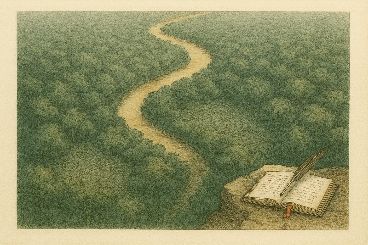
Hand-tinted engraving of a pale gold river winding through dense green forest canopy seen from above, faint circular and square enclosure lines showing through the foliage on both banks, and a small open handwritten chronicle with a quill resting on a rock ledge in the lower corner.
AI-generated editorial artwork

What is claimed

That Carvajal's 1542 chronicle describes a real world — populous, organized riverine societies on specific reaches — that epidemics, slave raids, missions and flight then destroyed and dispersed.

▸ read the rest

The version graded is the heterogeneous one: engineered corridors and hotspots in lightly occupied forest, with Carvajal credible in kind and unreliable in number.

Where the disagreement lives

The live dispute is proportion: how representative the dense river corridors were of a basin whose interfluves look lightly used. It turns on whether the sparse-forest findings survive critiques of their sampling and the erasure argument, both stated in papers this site has not yet checked.

▸ read the rest

It also turns on whether population totals survive their own assumptions, which manuscript branch the famous numbers belong to, and whether early or distant sites are being spent as evidence about 1542.

What would settle it

A preregistered corridor test comparing Carvajal's populated and empty reaches, classified from the manuscripts alone, against AD 1400–1650 archaeology and matched controls.

▸ read the rest

Beside it: a passage-by-passage collation of the manuscript branches; surveys of interfluvial forest chosen blind to archaeological promise; the 1650 Omagua headcount read from manuscript; and a calibration of how fast forest recovery erases human signals.

this edition · 30 September 2026

9 verdicts moved since the edition before it:

and 6 more, in the history below

The article was re-told: 2,331 words, from 3,733.

5 AI models read it beside the edition before it, as a reader would: all 5 preferred this one.

how the assessment has moved ↓how this edition was made →

Well supported

The judgment

ratified by 5 of 5 independent models · 30 September 2026

an AI-generated assessment · not reviewed by a human · ratified by independent models, which is not human review

The heterogeneous thesis is well supported: evidence of both signs converges on engineered, populous corridors in a lightly occupied forest, with Carvajal credible in kind, not number.

▸ the full reasoning

For the corridors: Aquiry earthworks at scale (AMZ-E001 on C004), dated a millennium too early for 1542 (AMZ-E003); southern-rim fortified villages of AD 1250–1500 (AMZ-E004 on C006); and Santarém, Marajó and Xingu systems running past contact (AMZ-E017, AMZ-E018, AMZ-E019 on C011). Engineered maize and year-round interfluvial fishing add to them (AMZ-E014 on C007; AMZ-E022 on C026). Independent 1538 and 1560 witnesses describe Carvajal's reaches (AMZ-E007 on C003). His extreme figures are branch-specific (AMZ-E005 on C002), in branches that are not independent (AMZ-E089 on C074). Negative records cap the garden Amazon: the river-distance gradient (AMZ-E010 on C013) and the thin intensive-use signal across fourteen regions (AMZ-E011 on C014). Population totals remain model envelopes (AMZ-E002 on C005; AMZ-E009 on C012). Several claims are stated in sources without checked evidence and are graded unresolved: the critiques that would discount the negatives (C021, C022), the modelling that would sharpen them (C020, C029), the weirs (C019) and the epidemic fade-out (C023). The character endorsements and the 'mentirosa' genealogy (AMZ-E080 on C068; AMZ-E105, AMZ-E106, AMZ-E109, AMZ-E110, AMZ-E111 on C017) concern the witness's credibility, not tests of content. C016 is graded on its dependencies' records. C017 is graded on AMZ-E007 and AMZ-E005 through its dependencies, and held provisional: no record tests his route at the contact horizon, and the corroboration arrives through one modern synthesis. The single record whose removal would most change the verdict is AMZ-E007. Without it Carvajal's credibility falls to weakly supported and the founding question to provisionally supported, though the archaeological mosaic stands. AMZ-E010 plays the equivalent role for the lightly occupied matrix.

the claims the case rests on

its weakest links

the steelman — the strongest argument this judgment does not answer

Every witness who saw the middle Amazon before the epidemics — Nunes in 1538, Carvajal in 1542, the ten Ursúa chroniclers in 1560 — reports the same unglamorous features on the same reaches: dense settlement, vast maize stores, long straight roads (AMZ-E007).

▸ read the rest

They wrote for different crowns, and convergence on mundane detail is what shared exaggeration rarely produces. The one feature that fails to converge, the giant warrior counts, is exactly what the manuscript branches show to be unstable (AMZ-E005). Proponents read this as the signature of a truthful observer whose numbers moved in transmission. They note that the earliest lie-charge targeted Orellana's relación, not the towns (AMZ-E080). Nothing checked contradicts the witnesses where they stood: the negative palaeoecology comes from interfluves and the west, not the Solimões bluffs (AMZ-E011). Denevan's bluff model predicts the alternation of dense and empty reaches the friar reports (AMZ-E006). Where records allow counting, declines of 62–88 percent are documented, by mechanisms that empty riverbanks (AMZ-E008), and the basin-wide radiocarbon proxy grows to the eve of contact (AMZ-E020). On this argument the burden lies on the skeptic; this assessment holds Carvajal provisional only because the corridor test has not been run.

5 AI models from different vendors each judged the evidence without seeing this judgment or one another. A model concurs when its verdict is within one step of the one above.

Gemini 3.8 Flash (Google)Well supportedconcursThe central thesis of the "Emptied Amazon" case—that Gaspar de Carvajal's 1542 chronicle described real, dense, and socially complex riverine populations that suffered rapid post-contact demographic collapse, embedded within a deeply heterogeneous landscape rather than a pristine wilderness or an unbroken basin-wide megalopolis—is well supported across historical, archaeological, and paleoecological lines of evidence.

The central thesis of the "Emptied Amazon" case—that Gaspar de Carvajal's 1542 chronicle described real, dense, and socially complex riverine populations that suffered rapid post-contact demographic collapse, embedded within a deeply heterogeneous landscape rather than a pristine wilderness or an unbroken basin-wide megalopolis—is well supported across historical, archaeological, and paleoecological lines of evidence. Steelman for the empty/pristine view: Skeptics correctly observe that the vast majority of Amazonia consists of terra firme where paleoecological soil cores (Piperno et al. 2024) find virtually no signs of intensive cultivation, extensive clearing, or recurring fires. Basin-wide spatial models (Peripato et al. 2023; Walker et al. 2023) show that approximately 80% of Amazonia had near-zero probability of earthwork construction, with archaeological sites heavily concentrated along modern rivers where survey effort is systematically biased. Furthermore, Carvajal's most extraordinary figures (warrior hosts of 50,000 and multi-league settlements) appear textually unstable, absent in Oviedo's early collation, and tainted by 16th-century tropes such as warrior women. Steelman for the emptied, engineered Amazon: The evidentiary revolution over the last two decades firmly dismantles the environmental-determinism model that claimed Amazonian soils could never sustain large-scale sedentary complex societies. LiDAR surveys, zooarchaeology, and archaeobotany demonstrate monumental earthworks in Acre (Pärssinen et al. 2026), intensive year-round maize monoculture and hydraulic networks in the Llanos de Mojos (Lombardo et al. 2025), landscape-scale managed fisheries (Blatrix et al. 2018; Prestes-Carneiro et al. 2019), and contact-era continuity at Santarém, Marajó, and the Upper Xingu (Stenborg et al. 2018; Schaan 2000). Crucially, independent 16th-century chronicles (Nunes in 1538; the Ursúa expedition in 1560) verify the qualitative social geography of dense settlements, vast maize stores, and engineered roads along the middle Amazon, while regional ethnohistorical records document catastrophic 60–88% declines by ~1700 driven by disease, slaving, and flight (Newson 2003). Sensitivity: The single evidence record whose removal would most threaten the case verdict is AMZ-E007 (Lopes et al. 2024, compiling Nunes and Ursúa accounts). Without it, Carvajal's qualitative descriptions would lack independent early colonial corroboration on the Solimões, shifting the historical argument back to an unverified eyewitness chronicle. However, the overall verdict of a heterogeneous, locally engineered, and post-contact depopulated Amazon survives even without AMZ-E007 because the archaeological evidence alone demonstrates dense contact-era occupations and substantial subsequent regional abandonment.

its steelman

The exact timing and transmission velocity of European infectious diseases ahead of direct European arrival remain unmeasured in the middle Amazon, leaving open the possibility that Carvajal witnessed late-phase ephemeral political expansions rather than stable, centuries-old riverine polities.

what it saw the case resting on

what it saw as the weakest links

run 2026-09-30-check-gemini-103112 · 2026-09-30 · Well supported · an AI seat, blind to the judgment · not human reviewed · per-claim verdicts on each claim page
GPT-5.6 Sol (OpenAI)Provisionally supportedconcursThe evidence provisionally supports the featured hypothesis in its restrained form: Carvajal probably encountered populous, organized riverine societies in particular reaches, but his largest numerical claims are unreliable, the pattern was not basin-wide, and the ledger has not directly demonstrated that the specific societies he saw were the ones later erased.

The evidence provisionally supports the featured hypothesis in its restrained form: Carvajal probably encountered populous, organized riverine societies in particular reaches, but his largest numerical claims are unreliable, the pattern was not basin-wide, and the ledger has not directly demonstrated that the specific societies he saw were the ones later erased. The strongest route-specific evidence is AMZ-E007: Nunes and the Ursúa-expedition accounts independently report dense middle-Amazon settlement, large food stores, travelled roads, and abundant resources. This is substantially more diagnostic than archaeological demonstrations that Amazonian environments could support complex societies. AMZ-E005 independently establishes that famous extreme figures occur in one manuscript branch but disappear from the Oviedo branch, supporting qualitative credibility without treating those figures as counts. The archaeological case is structurally strong but geographically and chronologically heterogeneous. AMZ-E004 documents a late pre-Columbian fortified settlement arc, while AMZ-E017 through AMZ-E019 show several substantial systems persisting into European contact or later. AMZ-E014, AMZ-E015, AMZ-E016, and AMZ-E022 demonstrate engineered agriculture and aquatic-resource use, rebutting a simple ecological impossibility argument. Conversely, AMZ-E010 and AMZ-E011 indicate that occupation was concentrated toward rivers and that many sampled terra-firme settings lack signals of intensive use. Those negatives support a mosaic rather than a continuous civilization, although survey accessibility, sparse coring, and proxy sensitivity remain serious limitations. Steelmanning the hypothesis, the convergence of independent sixteenth-century witnesses, contact-era settlement archaeology, and documented colonial depopulation makes invention an unnecessarily strong explanation. AMZ-E008 supplies measured regional declines of roughly 62–88 percent and multiple mutually reinforcing mechanisms, making a dramatic post-contact transformation entirely credible. Steelmanning the skeptical position, that reconstruction concerns Napo–Aguarico and Mainas rather than the precise middle-Amazon reaches at issue; many spectacular archaeological examples are elsewhere or centuries earlier; and no preregistered comparison yet matches Carvajal's populated and empty reaches against contact-horizon archaeology. Thus the local truth of AMZ-C010 does not by itself prove the featured corridor was emptied, and the local truth of early earthwork claims does not corroborate what Carvajal saw in 1542. The sensitivity hinge is AMZ-E007. Removing that record would eliminate the ledger's strongest independent, approximately route-matched corroboration of Carvajal's qualitative social geography, leaving mainly ecological possibility, analogical archaeology, and geographically displaced collapse evidence. The case verdict would then fall to mixed and therefore does not survive removal of AMZ-E007. Several catalog claims are also unresolved here because no evidence record states their results; that is an evidentiary-ledger limitation, not evidence that those claims are false.

its steelman

The strongest unanswered pro-hypothesis argument is Carvajal's alternating spatial map of populated and empty reaches: a route-blind contact-horizon survey finding greater archaeological intensity in his populated corridors than in matched empty corridors would provide uniquely specific corroboration that neither ecological analogies nor regional population models currently supply.

run 2026-09-30-check-gpt-103112 · 2026-09-30 · Provisionally supported · an AI seat, blind to the judgment · not human reviewed · per-claim verdicts on each claim page
Grok 4.5 (xAI)Well supportedconcursThe ledger evidence overturns the twentieth-century default of a uniformly poor, near-empty Amazon incapable of complex societies, while equally rejecting any basin-wide continuous civilization.

The ledger evidence overturns the twentieth-century default of a uniformly poor, near-empty Amazon incapable of complex societies, while equally rejecting any basin-wide continuous civilization. Multiple independent lines establish dense, engineered, and politically organized occupations along favored corridors and hotspots into or near the contact era: LiDAR and survey document thousands of earthworks and fortified villages across southwestern and southern-rim Amazonia (C004, C006), Casarabe maize monoculture with hydraulic infrastructure (C007), dark earths and managed forests (C008), year-round interfluvial fisheries (C026), and settlement systems on the Belterra Plateau, Marajó, and Upper Xingu occupied to the seventeenth or eighteenth century (C011). Carvajal’s 1542 qualitative picture of populous riverbank settlements, stores, roads, ceramics, and multi-settlement territories alternating with empty stretches is corroborated by independent sixteenth-century witnesses (Nunes and the Ursúa accounts, C003) and matches the bluff-model geography of dense reaches at channel-bluff junctions (C001). His extreme warrior and village-length figures are textually unstable, present only in one manuscript branch (C002), so they cannot be treated as counts; the qualitative social geography remains credible (C017). Post-contact decline is documented as catastrophic yet uneven and multi-causal in upper-Amazon provinces (C010), with settlements still occupied at contact then emptying. Simultaneously, basin-scale predictors and palaeoecological syntheses show river distance dominating occupation probability and little to no intensive annual-crop, clearing, or anthropic-soil signal across most sampled terra-firme and interfluvial settings (C013, C014). Population numbers remain model-family constructs sharing assumptions rather than independent censuses (C005, C012, C015). The resulting picture is precisely the heterogeneous landscape stated in C016: substantial sedentary engineered populations along rivers, floodplains, savannas and bluffs, embedded in a lightly occupied forest matrix. This makes Carvajal’s kind of world locally real and later emptied, without requiring either pristine wilderness or uniform high density. Chronology caveats matter: Aquiry peak density is a millennium before Orellana, and some raised-field use was intermittent flood-risk mitigation rather than permanent intensive farmland. Open tests (route-matched archaeology, promise-blind interfluve densities, dependency-corrected demography) remain, but the directional inversion of the old impossibility argument is already secured by the measurements and replications in the ledger. Verdict hangs on the convergence of archaeology, ethnohistory, and negative palaeoecology rather than any single spectacular site or number.

its steelman

The still-unexecuted preregistered Carvajal-corridor test leaves his specific populated-versus-empty reach map unverified against contact-horizon archaeological intensity; a null spatial match would reduce qualitative credibility to generic plausibility without route-level confirmation.

run 2026-09-30-check-grok-103112 · 2026-09-30 · Well supported · an AI seat, blind to the judgment · not human reviewed · per-claim verdicts on each claim page
GLM 5.3 Flash (Z.ai, via Venice)Well supportedconcursThe case's structural claims survive an independent pass.

The case's structural claims survive an independent pass. The textual core is solid: Carvajal's qualitative social geography is documented in verified scholarship (AMZ-C001), the extreme numbers are demonstrably manuscript-branch artifacts rather than counts (AMZ-C002, verbatim-verified), and — the single most important fact in the ledger — the mundane load-bearing features of his picture (dense settlement, vast food stores, long straight roads, renowned ceramics) were independently repeated by the 1538 Nunes entry and the ten 1560 Ursúa accounts, witnesses hostile to one another and writing for different crowns, none of whom repeats his extreme figures (AMZ-C003/E007). The archaeological record independently establishes engineered, fortified, contact-era-occupied settlement systems (C004, C006, C007, C011) and, symmetrically, genuinely sparse interfluves (C013, C020, C029), which together carry the heterogeneity synthesis (C016). Nothing in the ledger contradicts any claim. The honest weaknesses are on the negative side: the sparse-matrix evidence (C013, C014) rests on samples that inherit river-access survey bias and, per the Upano erasure finding (C022), palaeoecological absence is time-graded and can be a false negative — so the matrix-density parameter of the mosaic remains an estimate from biased samples, exactly as the unperformed AMZ-R003 concedes. The demographic layer is deliberately self-undermining and right to be: Denevan's self-rejection (C012) and the Aquiry fivefold internal span (C005) show why totals must not be quoted without their assumption sets; the SPD carrying-capacity result (C015) is a proxy with stated biases. Sensitivity: removing AMZ-E007 (the Nunes/Ursúa corroboration) would be the single most damaging cut — the qualitative-credibility claim C017 would fall from well_supported to weakly or provisionally supported, resting on Carvajal's text alone plus archaeology from other regions, and the case verdict would degrade from well_supported to provisionally_supported. The verdict does not hang on one thread only because E007 exists; it is the load-bearing record. The collapse-between-visits reading for Carvajal's specific reaches remains a well-motivated extrapolation from upper-Amazon provinces (C010, C023), not yet a demonstration — which is what AMZ-R001 and AMZ-R005 exist to test.

its steelman

No evidence record in the ledger bears directly on the middle-Amazon floodplain reaches Carvajal described at the contact horizon: the sparse-Amazon negatives come from terra firme and interfluves, and AMZ-C022 (Bush 2025, Upano) demonstrates that forest recovery can largely erase a real pre-Columbian occupation signal while AMZ-R008's decay-curve calibration has never been run. Combined with the convergent independent testimony of Nunes and the Ursúa accounts on mundane, checkable details, a proponent can correctly say that nothing currently in the ledger can falsify a densely populated, organized corridor on the middle Amazon in 1542 — and that the documented 62–88% collapses in adjacent provinces (AMZ-C010) make a catastrophic die-off between visits the parsimonious reading of the later silence.

what it saw the case resting on

what it saw as the weakest links

run 2026-09-30-check-glm-103112 · 2026-09-30 · Well supported · an AI seat, blind to the judgment · not human reviewed · per-claim verdicts on each claim page
Opus 5.5 (Anthropic)Provisionally supportedconcursI take the featured hypothesis from the case title and its framing question.

I take the featured hypothesis from the case title and its framing question. The crowded, organized river world Carvajal described in 1542 was real, and post-contact collapse emptied it. The rival readings are that he invented it or merely exaggerated it. The ledger splits the hypothesis into three legs of unequal strength. The first leg, that the world existed, is the best supported. It rests chiefly on E007. The sixteenth-century accounts compiled there come from two other expeditions: Nunes's entry of 1538 and the Ursúa expedition of 1560. They describe dense settlement, vast food stores, and long straight roads on the Machiparo/middle-Solimões reaches Carvajal named. None of them repeats his extreme numbers. That is the signature of a qualitatively reliable witness whose figures are not counts. It matches Denevan's collation, which places the 50,000-, 10,000- and 8,000-warrior figures and the league-long villages in one manuscript branch only (E005). Archaeology places organized societies near his lower route across the contact horizon itself. The Belterra sites, with dark earths, ponds, and trodden roads, run up to seventeenth-century colonization (E017), and Marajoara continuity at Cacoal runs to 1650 (E018). Off-route systems show substantial late populations elsewhere (E004, E019). The radiocarbon proxy rises toward carrying capacity before colonization (E020). The earliest 'mentirosa' charge targeted Orellana's relación. On Medina's reading it concerned the Amazons, not the settlements (E080, E082, E099). Those Medina-derived records rest on a single reading that no second reader has checked. Oviedo's and Medina's character endorsements carry no diagnostic weight, and I give them none. Much of the celebrated new archaeology does not bear on this leg. The Aquiry peak is AD 100–300 (E003), and Casarabe ends around 1400 (E014). These results defeat the old argument that Amazonia could not support complex societies. Spending them as corroboration of 1542 would be a chronology error. The population models are also assumption-driven. The Aquiry estimate spans roughly fivefold across its own alternatives (E002). The southern-rim figure scales 20- to 50-fold from counted sites (E004). Denevan abandoned his own method while retaining its order of magnitude (E009). No count exists that could vindicate or refute Carvajal's figures. The second leg, that the world was emptied, is the weakest. E008 documents catastrophic, mixed-cause declines of about 88% and 62–64% by circa 1700. These include flight from exposed riverbanks, which is the right mechanism for later silence along the rivers and a reason to prefer 'emptied' over 'died'. But these are upper-Amazon provinces, and E008 itself flags extension to the middle and lower Amazon as extrapolation. The fade-out mechanism (AMZ-C023) has no evidence record. The ledger holds no collapse series for Carvajal's reaches. It does not itself document their later emptiness. The support is circumstantial: the systems dated across 1542 all end in the colonial centuries. Where I credit this leg beyond Newson's provinces, I lean on the general background that post-contact collapse was widespread in the Americas. That is a prior, not ledger evidence. The Ursúa witnesses also show the middle Solimões still crowded in 1560. So any emptying happened over the following century, not between Orellana and Ursúa. The third leg is scale. The sparse-matrix evidence (E010, E011, and the basin models) is exposed to survey bias, thin sampling (AMZ-C021), and possible erasure (AMZ-C022). Still, none of it contradicts a corridor reading. It is what Carvajal's own empty stretches and the bluff model (E006) predict. It does rule out an emptied basin-wide civilization. Steelmanning against the hypothesis: - Corroboration covers two stretches of a very long route. - Nunes survives only in a later letter. - The ten Ursúa accounts come from one expedition. - The southern-rim horizon closes around 1500, before Orellana, and the ledger does not explain this. - The collapse is borrowed from other provinces. Steelmanning for it: nothing in the ledger contradicts the corridor version, and the rivals fare worse. 'Invented' is contradicted by independent testimony and contact-era archaeology. 'Exaggerated' survives only for numbers that were never counts. AMZ-C010 and AMZ-C003 are both load-bearing and weakest links. AMZ-C010 is not doubtful; its scope simply stops short of Carvajal's reaches. AMZ-C003 hangs on a single record. No record in the packet is marked provisional, and the rejected tombstones E086, E107, and E108 are disregarded. Verdict: provisionally_supported. 'Real' is well supported for specific reaches. 'Emptied' rests on regional analogy and occupation end-dates. Sensitivity: the most load-bearing record is E007. Without it, the reaches carrying the account's most famous descriptions would be uncorroborated. The case would lean on lower-Amazon archaeology alone (E017, E018), and I would lower the verdict to weakly_supported. The verdict does not survive E007's removal at its current level; it hangs substantially on that one thread.

its steelman

The sequence the emptied-world hypothesis predicts is the one the ledger shows wherever it can be dated. Three separate parties attest a populated Machiparo/middle-Solimões reach: Nunes in 1538, Carvajal in 1542, and the Ursúa expedition in 1560. The accounts compiled in E007 call it one of the most densely inhabited parts of the river, with vast food stores and long roads. Every system dated across 1542 ends during colonial expansion: Belterra near Santarém at seventeenth-century colonization, Cacoal on Marajó at 1650, and the Upper Xingu towns around 1770. In the provinces the ledger has colonial records for, populations fell 62–88% by about 1700 through epidemics, raiding, missionization, and flight from the riverbanks. My assessment stops at provisionally_supported because the ledger lacks a middle-Amazon collapse series. Yet it offers no competing explanation for how a corridor independently described as crowded through 1560 became the empty river of the later record. The downgrade rests on missing records, not on any record showing that these reaches were not emptied.

what it saw as the weakest links

run 2026-09-30-check-opus-103112 · 2026-09-30 · Provisionally supported · an AI seat, blind to the judgment · not human reviewed · per-claim verdicts on each claim page

Claim by claim, against this judgment: 3 of 27 exact, 18 within one step, 6 split. Split — where review should start: AMZ-C019 · AMZ-C023 · AMZ-C020 · AMZ-C021 · AMZ-C022 · AMZ-C029.

run: 2026-09-30-edition-094541model: claude-opus-5-5prompt: edition-v14date: 2026-09-30

5 accounts, side by side · the edition of 2026-09-30

  1. 1Invention: Carvajal fabricated or grossly inflated a riverine world the Amazon could never have supported
  2. 2A murdered world: Carvajal described faithfully what he saw, and epidemics, slave raids, missionization and flight destroyed and dispersed it before later travelers arrived
  3. 3The garden Amazon: the whole basin, interfluves included, was densely peopled and intensively managed by many millions
  4. 4The mosaic: dense, engineered corridors and hotspots set in a lightly occupied forest matrix, with Carvajal qualitatively honest and numerically unreliable
  5. 5The modest skeptic: real but modest societies on the richest corridors, population totals that are model artefacts, and a later emptiness that partly records a modest reality rather than only a collapse

the article · a marked sentence opens the exact claim behind it

about 10 minutes

The evidence now lands between the extremes. Witnesses of 1538 and 1560 describe the same kind of world on the same reaches. Archaeology shows engineered, populous societies in favored places, some still occupied when Europeans arrived, and colonial records document catastrophic collapse. But the same surveys find the forest between the rivers lightly used, and his most famous numbers differ between manuscripts. No one has yet tested his populated reaches against the archaeology of his own century. How representative his river was is the open question.

Five readings

  • Invention. Carvajal made up or grossly inflated a world the Amazon could not support. This predicts no independent witnesses and no large settlements of his century on his route.
  • A murdered world. He reported faithfully; epidemics, slave raids, missions and flight destroyed that world before the next visitors came. This predicts dense archaeology of his era in his populated reaches, and a collapse that emptied riverbanks in particular.
  • The garden Amazon. The whole basin, including the forest between rivers, was densely peopled and managed by many millions. This predicts signs of intensive use nearly everywhere soils are cored.
  • The mosaic. Dense, engineered corridors and hotspots sat in lightly occupied forest; Carvajal was honest in kind and unreliable in number. This predicts strong signals by rivers and bluffs and weak ones between them.
  • The modest skeptic. The societies were real but smaller. Orellana travelled the richest corridors, archaeologists look where they can see, and the later emptiness partly records a modest reality. This predicts population totals that dissolve under their own assumptions, and negative evidence that survives better sampling.

The first reading has not survived in the form it began. The other four are live, and what separates them is proportion.

One chronicle, two texts

Nor are the branches independent. Oviedo says he filled out the friar’s account with particulars learned in Santo Domingo from Orellana and the gentlemen who came with himC074. Where the texts differ, the difference may be the friar’s revision, a copyist’s, or the captain’s memory. The numbers may have grown in one line of copying or been trimmed in the other. What is established is instability, not direction. The sensible reading is neither “believe him” nor “dismiss him”: trust the kind of world he described, and refuse his arithmetic.

▸ claims behind this paragraph (1)

There are limits. Nunes survives only in a letter written some fifteen years later. The witnesses reach this site through one modern synthesis. And the fortifications and war fleets of Carvajal’s story are not among what they share. A 2018 study checked the chronicle’s geographic landmarks against the river and judges the manuscript a trustworthy sourceC065. Only its abstract has been read here, and the abstract says nothing about the numbers.

▸ claims behind this paragraph (1)

What the lasers found

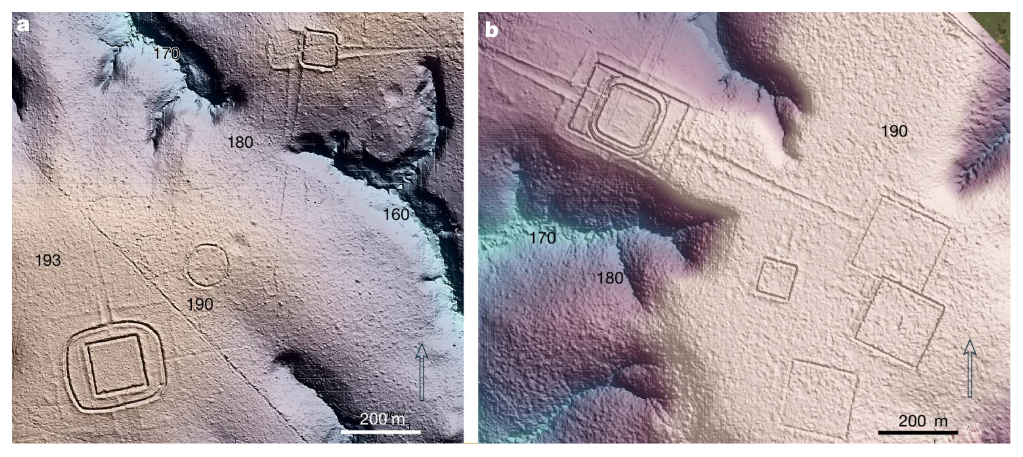
Six LiDAR-derived terrain panels showing precolonial earthwork types in southwestern Amazonia — ditched geometric enclosures, embanked quadrilaterals, and mound structures — each rendered as shaded relief with its topographic context.

plate I · published figure (LiDAR terrain models) — duotone applied in display; original unmodified

Diverse Aquiry earthwork types with their topographical contexts — Figure 2 of Pärssinen et al. 2026, the open-access Nature study that documented 432 earthworks by canopy-penetrating LiDAR and predicted roughly 24,000–30,000 across the ~183,000 km² Aquiry region (AMZ-C004, AMZ-C005).

Pärssinen, M., Kalliola, R., Ranzi, A. et al. · 2026 · source · CC BY 4.0

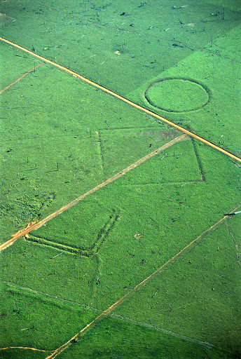
The modern turn began with geometric ditches emerging from cleared pasture in the Brazilian state of Acre. It accelerated when LiDAR, airborne laser scanning that sees through the canopy to the ground, went looking under the trees. The survey program led by Martti Pärssinen and Alceu Ranzi documented 432 earthworks, 396 of them previously unknown, and projects roughly 24,000 to 30,000 across a 183,000-square-kilometer cultural region, the AquiryC004. A 2023 model built from earlier finds put the number still undiscovered in the whole basin at 10,000 to 24,000. The two studies define earthworks differently, so they do not contradict each other. But published totals differ several-fold, and only a survey chosen blind to promise can tell which is calibrated.

▸ claims behind this paragraph (1)
Aerial photograph of a geometric geoglyph in cleared Acre pasture — a circular ditched enclosure joined to a square enclosure by a straight embanked avenue, with cattle tracks crossing the grass around it.

plate II · aerial photograph — duotone applied in display; original unmodified

The Fazenda Colorada geoglyph site, Acre, Brazil — one of the ditched geometric enclosures of the Aquiry earthwork tradition, visible at ground level only because deforestation exposed it (AMZ-C004).

Sanna Saunaluoma · source · CC BY-SA 3.0

Transparency. The 2026 study’s funding statement reads: “The project and data collection were funded by a grant from E. Jhong (USA).” That is this site’s founder. The Athanatos Foundation, with which he is associated, is thanked for administrative help. It is one reason the paper’s population figure appears here at its most assumption-exposed.

Engineered ground

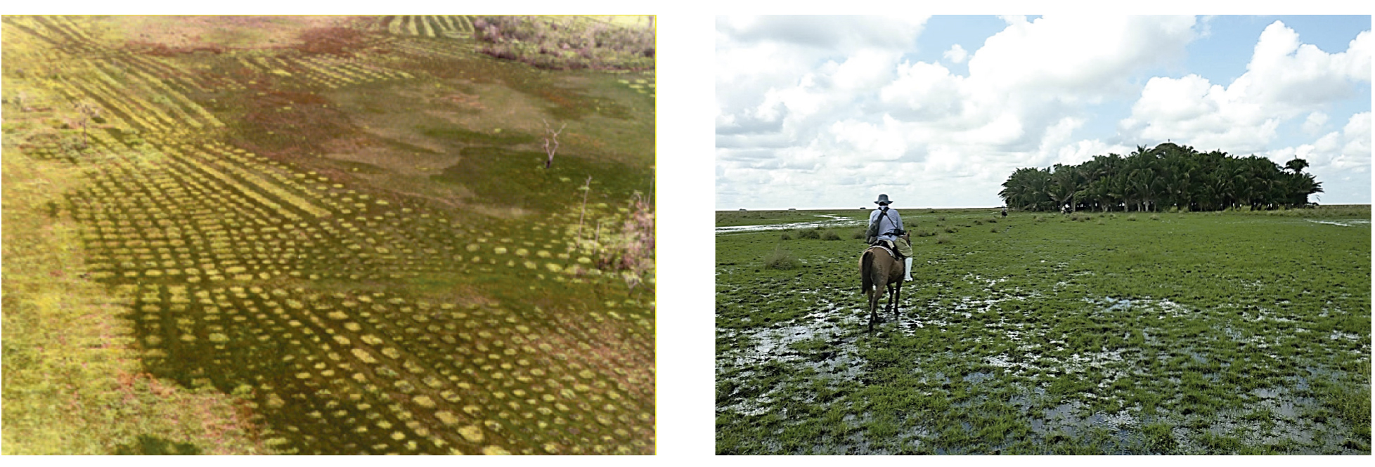
Two aerial photographs side by side — on the left, ranks of low rectangular pre-Columbian raised fields patterning a seasonally flooded coastal savanna in French Guiana; on the right, a rounded human-made forest island standing in open flooded savanna in the Llanos de Mojos, Bolivia.

plate III · published figure (aerial photographs) — duotone applied in display; original unmodified

The lasting ecological signature of pre-Columbian landscape engineering in seasonally flooded savannas: wetland raised fields (French Guiana, left) and an anthropogenic forest island (Llanos de Mojos, Bolivia, right) (AMZ-C007, AMZ-C008).

Stéphen Rostain; Doyle McKey · source · CC BY 4.0

“What could they all have eaten?” was always the strongest scientific objection, and it now has direct answers. In Bolivia’s Llanos de Mojos the Casarabe culture drained its savanna with canals for the wet season and farm ponds for the dry, and microscopic plant remains in 178 soil samples show maize everywhere, which the team reads as intensive year-round monocultureC007. More broadly, dark earths, raised fields, forest islands and clusters of domesticated trees around old sites record long human reshaping of the landC008. A formal critique, though, argues that five post-Columbian centuries did more than the earlier ones to produce the modern tree pattern.

▸ claims behind this paragraph (2)
Excavated soil face showing deep black earth flecked with charcoal and pale ceramic fragments beneath forest litter, markedly darker than the pale tropical subsoil beneath it.

plate IV · photograph — duotone applied in display; original unmodified

Amazonian dark earth (terra preta) beneath forest in Brazil — nutrient-enriched anthropogenic soil, rich in black carbon and ceramic sherds, formed by long-term human occupation (AMZ-C008).

Bruno Glaser · source · CC BY 4.0

The diet itself is in the ground. A mound fifty kilometers from the Mamoré River held more than 17,000 fish remains, including dry-season species that survive in small ponds: fishing all year, far from the big riverC026. One site is an existence proof, not a census. And the Casarabe world ended around 1400, so it answers the impossibility argument without describing 1542. Nor is engineering a headcount: the raised fields of the Bolivian lowlands, carefully dated, were built and used intermittently, plausibly as flood insurance where nothing else would doC009.

▸ claims behind this paragraph (2)

How many people?

The disappearance

The limit is that these counts come from upper-Amazon provinces with mission records. The Solimões reaches where the dispute lives have no such reconstruction. The nearest thing, a Franciscan’s headcount of the Omagua around 1650, survives in a 1900 edition whose printed numeral is garbled.

The sparse Amazon

Everything above could be true and the garden Amazon still false. Across 7,363 recorded sites, distance from a river is the strongest predictor of pre-Columbian occupation, with the land between rivers markedly sparserC013. And soil cores from fourteen regions of the western Amazon mostly show closed forest with little or no sign of crops, clearing, dark earths, tree planting or repeated fireC014. These skeptics are not reviving the impossibility thesis; they are defending proportions.

▸ claims behind this paragraph (2)

The negatives have critics, equally unchecked here. A formal reply argues that the “sparse west” rests on about 300 soil cores in five clusters, some 1.17 cubic meters of sediment standing for two million square kilometersC021. A study in Ecuador’s Upano Valley reports that forest regrowth largely erased the pre-Columbian signal while the later colonial one survivedC022.

▸ claims behind this paragraph (2)

But the Upano occupation ended between 300 and 600 CEC061, with some mounds reoccupied until about 1200C062. The erased signal was roughly a thousand years old. Would a four-century-old signal, from a riverbank emptied in the 1600s, also vanish? The erasure argument needs that answer and does not have it. Meanwhile the site database behind the river gradient reflects where archaeologists could reach.

What would decide it

  • The corridor test. Classify each reach of the 1542 route as populated or empty from the manuscripts alone, then compare AD 1400–1650 archaeology there with matched controls. The murdered world and the mosaic predict a strong match; the modest skeptic predicts real settlement no denser than other bluff sites; invention predicts nothing.
  • The witness table. Collate the branches passage by passage, marking what Oviedo owed to Orellana. If only the numbers are branch-specific, the friar’s standing hardens, and the direction of drift appears.
  • Blind surveys. Run laser scans and gridded cores in forest blocks chosen without regard to known sites. The garden Amazon predicts densities near riverine ones; the mosaic, a real but low background; the skeptic, near zero.
  • The 1650 headcount. Read the Madrid manuscript behind the garbled edition. Tens or hundreds of men would date an emptied corridor within a century of Carvajal; low thousands would mean a province still standing.
  • Erasure calibration. Score human signals in soils beside sites with known end dates, against years since abandonment.
  • Calibration and timelines. Stratified laser surveys would calibrate the earthwork totals. Population estimates should be re-derived under common assumptions. And collapse timelines are needed for the Solimões.

Where the case lands

Who kept the question alive

Years before the 2026 results, Graham Hancock’s *America Before* gave seven chapters to the Amazonian discoveries, the Acre geoglyphs among them, and his 2024 television series put Pärssinen and Ranzi before a mass audienceC018. Outsider status is evidence in neither direction, and his lost-civilization thesis is not what this evidence supports. But an honest genealogy records who kept the question in view while the instruments caught up.

the argument ladder

evidence for a lower rung does not automatically climb

Mechanism

Could it have been done? Ingredients, chemistry, and method.

Observation

What is actually there? Measurements, records, and anomalies.

Evidence highlights

The strongest records on each side, structurally symmetric. Every record separates what the source states from what we infer. Browse the full ledger (48 records) →

strongest supporting

Supports· decisiveAMZ-E009

Denevan rejects his own habitat-density method while retaining the order of magnitude

what the source states
"Consequently I now reject the habitat-density method I used in the past to estimate a Greater Amazonia population in 1492 of from 5.1 to 6.8 million. There was too much variability in densities in each habitat to be able to formulate meaningful average densities on the basis of a few sample densities." And: "I nevertheless still believe that a total of at least 5 to 6 million is reasonable."
what we infer
A number can remain plausible while the argument that generated it fails — the clearest documented example of why this case audits estimate dependencies rather than quoting totals.
Supports· strongAMZ-E001

LiDAR documents 432 earthworks and delimits a 183,000 km² Aquiry region

what the source states
"Our new LiDAR data, obtained from 10 ALS lines, document 432 earthworks, of which only 36 were previously known." LiDAR reveals "five times more earthworks in the deforested areas of block 1 than we had previously found along the same lines using satellite imagery"; the geographic circumscription "produced an area of about 183,000 km²," and the study estimates "approximately 24,000–30,000 earthworks, of which about two thirds belonged to the Aquiry."
limitations
  • The 24,000–30,000 figure is a block-extrapolation from sampled densities, as the paper states.
Supports· strongAMZ-E002

The paper's own single-family sensitivity collapses the population headline roughly fivefold

what the source states
"If, as said, about 25–60% (4,165–10,000) of these earthworks were in use in 100–300 ad, and if an average earthwork required 300 people to build and maintain it, we arrive at a total population of about 1.25–3 million." And: "Only if the very unlikely estimation that each approximately 25-m long house foundation (mound) belonged to a single family were true would the population be about 250,000–600,000 people without the invisibility effect of laser penetration, which would raise the population, in this case, to approximately 315,000–760,000."
what we infer
The estimate's span across its own stated assumptions — roughly fivefold — is the honest error bar, and it is what this case displays rather than the headline alone.
limitations
  • The authors label the single-family reading 'very unlikely'; the sensitivity is theirs, the emphasis is ours.

strongest undermining

The best conventional explanation

steelmanned — the account the featured hypothesis must beat

The modern skeptic concedes major regional societies and argues limits. Orellana travelled the richest corridors: the bluff-and-channel settings where settlement concentrated, and where archaeology looks and preserves. Corroboration there cannot license basin-wide extrapolation. Sampled interfluvial and western soils show little cultivation, clearing or soil modification, and river distance dominates the known site record. The famous population totals are model outputs whose assumptions do most of the work, as their authors say. Carvajal's extreme figures are unstable across manuscript branches that are not independent, consistent with a truthful observer whose numbers changed in the telling. On this view the mosaic is real but modest: dense hotspots, a thin matrix, and a chronicle honest in kind and unreliable in number, describing a world smaller than legend and then genuinely destroyed.

What would change our mind

The case does not end in a verdict; it ends in the studies that would move it, in the order this edition judges they would move it most. A result in either direction counts.

AMZ-R001Prize or grant · Desk

The Carvajal corridor test: preregistered comparison of his populated and empty reaches against contact-horizon archaeology

Classify every reach of the 1541–42 route as populated or empty from the manuscript witnesses alone — before consulting archaeological layers — with route and palaeochannel uncertainty modeled as probability corridors — tributary identifications remain tentative in the scholarship (the "Río de la Trinidad" carries an explicit question mark in the recovered literature). Then compare contact-horizon (AD 1400–1650) archaeological intensity in his populated corridors against matched control reaches. Freeze the reach classifications, matching protocol, and outcome measure first; collect second.

expected information gain

Converts a 480-year-old credibility dispute into a falsifiable spatial prediction. A positive result would be the strongest possible vindication of the account's qualitative reliability; a null would cap it — either way the largest open question in this case closes.

would update:AMZ-C001AMZ-C017
AMZ-R002Publication prize · Desk

Synoptic manuscript-witness table for the Carvajal account

A passage-by-passage collation of the Muñoz/T'Serclaes–Medina and Oviedo witnesses, separating what every branch shares (the qualitative bedrock) from what only one branch carries (the famous figures), with each downstream citation in the literature re-anchored to the branch it actually quotes.

expected information gain

Every argument about "what Carvajal said" currently depends on which edition a scholar happened to cite; the table would end that ambiguity permanently and likely reclassify several famous claims.

would update:AMZ-C002
AMZ-R003Small grant · Field

Promise-blind interfluve surveys: measuring the matrix, not the hotspots

Survey transects (LiDAR plus ground-truthing plus gridded soil coring) across interfluvial blocks selected by a sampling frame blind to archaeological promise, to estimate occupation density where neither discovery bias nor spectacular-site selection operates — with proxy-sensitivity controls so negative results count only where the method could have detected occupation.

expected information gain

The mosaic model's open parameter is the matrix density; both the positive record (sites) and negative record (sparse cores) are currently biased samples. This is the direct measurement.

AMZ-R007Small grant · Desk

Read the Biblioteca Nacional manuscript of Laureano de la Cruz to fix the Omagua headcount garbled in the 1900 edition

Object: the 62-folio manuscript of Laureano de la Cruz's 'Nuevo descubrimiento del río de Marañón' in the Biblioteca Nacional de España (the 1900 Madrid editor's source), and a page image of p. 94 of the 1900 edition. Measurement: the exact numeral the author gives for the men found in the Omagua province ('no hallamos ... indios cabales'), which the Internet Archive OCR renders as '10', together with any marginal or textual variants; secondarily, confirm the 34-village count and the 200-league extent. Decision rule: if the manuscript reads a figure in the low thousands (as a tertiary snippet gives, ≤5,000), the province held roughly 1,000–2,500 households in 1650 and the proposed claim on Laureano's 34 villages can carry a number; if it reads tens or hundreds, the Omagua corridor was near-empty a century after Carvajal and the murdered-world reading of AMZ-C017 gains a dated resident witness; either way the result moves AMZ-C010's geographic reach (Solimões vs upper-Amazon provinces) and supplies the 1650 point in the province timeline. Also record whether Laureano gives any village count for the reaches below the Putumayo mouth he did not visit.

expected information gain

Converts an OCR-uncertain figure into the only seventeenth-century resident headcount for Carvajal's Omagua reach; distinguishes 'a province of a few thousand' from 'a province of a few hundred' in 1650, which is the magnitude the modest-skeptic and murdered-world accounts disagree about.

would update:AMZ-C017AMZ-C010
▸ 4 more studies on the agenda
AMZ-R008Prize or grant · Lab

Calibrate palaeoecological erasure against time since abandonment using sites with dated occupation ends

Object: sediment or soil profiles adjacent to Amazonian occupation sites whose end dates are archaeologically fixed — Upano (occupation ending 300–600 CE, with Huapula reoccupation to ~1200 CE), Casarabe (~1400 CE), Belterra Plateau near Santarém (to the seventeenth century), Marajó Cacoal (to ~1650) and Upper Xingu (to ~1770). Measurement: in each profile, the presence and magnitude of anthropogenic indicators (crop phytoliths, charcoal influx, soil-nutrient and pottery-fragment signals, disturbance-taxon pollen) in the occupation-age horizons versus the post-abandonment and Colonial horizons, scored by a common protocol, then plotted against years since abandonment. Decision rule: if sites abandoned 350–400 years before present retain clear occupation signals while Upano's ~1,000-year-old signal is lost, then the erasure documented at Upano (AMZ-C022) is time-dependent and cannot be used to discount contact-era palaeoecological negatives in reaches depopulated in the 1600s, strengthening AMZ-C014's negatives for those reaches; if signals are also largely erased at the ~400-year sites, AMZ-C022 applies generally and AMZ-C014's negatives in terra-firme settings are weakened as evidence of absence; an intermediate result yields a decay curve that grades the negatives by age.

expected information gain

Turns the 'time-graded erasure' argument from an analogy into a measured decay function, deciding how much weight contact-era palaeoecological absence can bear.

would update:AMZ-C022AMZ-C014
AMZ-R006Small grant · Field

Blind, probability-stratified LiDAR test of the competing earthwork-density predictions

Select LiDAR survey blocks at random within strata defined by the 2023 basin-wide probability surface (0–1%, 1–10%, 10–25%, ≥25%) and, inside the Aquiry area, by the 2026 study's regional model — choosing blocks before any archaeological knowledge of them is consulted and registering the selection. Fly and inspect each block with a fixed detection protocol and independent expert confirmation, then record earthworks per km² per stratum. Compare the observed densities with the densities each model implies for those strata. Observed densities in the 0–1% stratum at or near zero and rising monotonically with predicted probability would support the basin-wide model's calibration claims (proposed at intake and not admitted) as calibrated; systematic under-prediction inside the Aquiry area would favour the 2026 regional total in AMZ-C004 over the basin-wide one, and the reverse would favour the lower. Either result narrows the several-fold spread between published earthwork totals that AMZ-E038 records.

expected information gain

Directly calibrates two predictive models whose totals differ several-fold, using sampling chosen blind to promise — the earthwork counterpart of AMZ-R003, and the only way to tell whether the 24–30k regional figure and the 10–24k basin figure can both be right.

would update:AMZ-C029AMZ-C004
AMZ-R004Publication prize · Desk

Dependency-corrected re-derivation of Amazonian population estimates

Group every published basin and regional estimate into its model family (habitat-density, ethnographic back-projection, documentary, settlement/house-count, dark-earth scaling, radiocarbon proxy), identify shared assumptions, and re-derive the families under a common assumption set with explicit sensitivity envelopes — Denevan's self-rejection (AMZ-C012) and the Aquiry fivefold span (AMZ-C005) as the template.

expected information gain

Would replace the misleading spread of "competing censuses" with an honest map of which numbers are actually independent — probably narrowing the defensible range substantially.

would update:AMZ-C005AMZ-C012
AMZ-R005Prize or grant · Desk

Province-by-province collapse timelines for the middle and lower Amazon

Extend Newson-style documentary reconstruction (epidemics, slave raids, missionization, relocation, flight — dated and sourced per province) from the upper-Amazon provinces where it exists to the Solimões reaches Carvajal described, testing quantitatively whether documented decline and relocation suffice to turn his 1542 into the emptier later record.

expected information gain

The reconciliation argument currently borrows regional ratios from provinces with records; establishing them where the dispute actually lives would close the loop — or break it.

would update:AMZ-C010AMZ-C017

How the assessment has moved

Trust comes partly from showing changed minds. Each entry is an edition that changed a verdict, with the word before and the word after — a reversal included.

  1. 9 verdicts moved

    and 1 more

  2. 5 verdicts moved

The change log

Aletheia records every change to a case: what changed, why, and who made it — including the AI's role. The latest:

  • Review note #358 (GPT-5.6 Sol seat on #357, §3.2, §3.6, §3.8, §3.13), recorded against assessment 2026-09-19-edition-042009, which edition-2026-09-19-042009 adopts by content hash and…
  • Correction by the operator: the builder-attribution claim added on 2026-09-17 as AMZ-C066 is AMZ-C086, and its evidence added as AMZ-E078 is AMZ-E115; AMZ-E115 cites AMZ-C086; the…
  • Amendment by the operator to edition edition-2026-09-17-142106 (field: article), recorded in the edition's amendments: the sentence that cited AMZ-C061 for both the dating and the builders…

All 25 entries, and every run with what it refused and why →