Deep Memory/ Clues to a deeper past
A second inquiry · Submerged landscapes

Another world
lies offshore.

The sea covered coastlines, rivers and places people once lived.

What survives—and what can today’s data reveal?

Begin with the shape of the land

Look beyond today’s coast.

Modern relief · depth experiment.
No ancient date assigned.

Modern elevation baseline
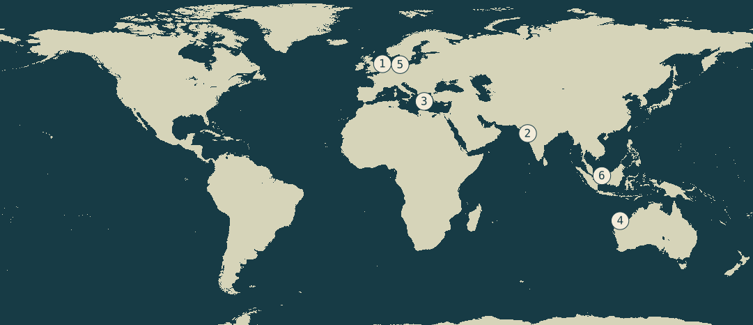
World relief from NOAA ETOPO1; present non-negative elevations in light green, negative elevations in blue
Present relief · an older global compilation
Depth screen · 0 to −60 m
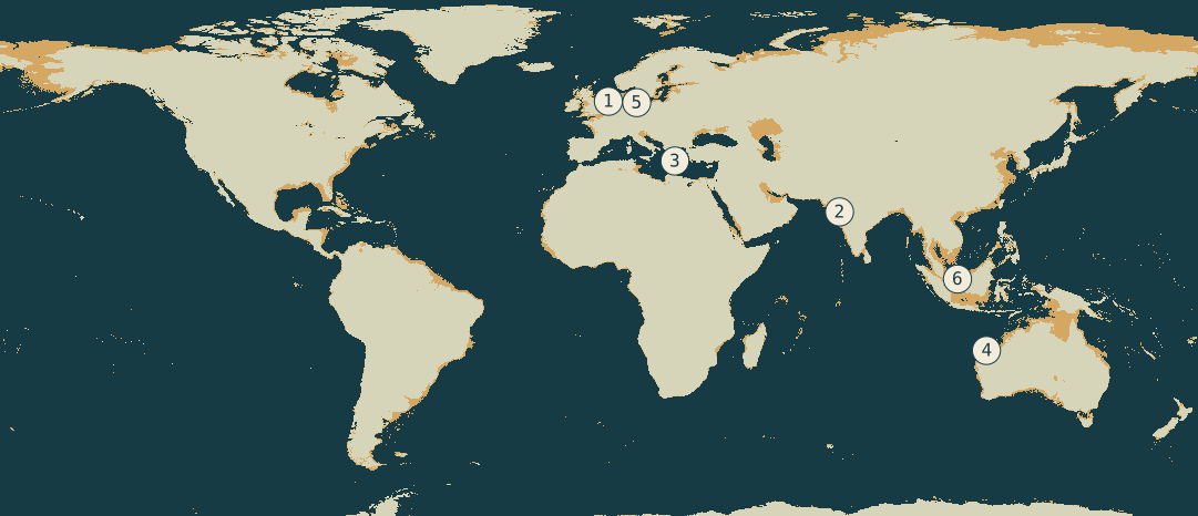
The same world relief with elevations from minus 60 metres to zero highlighted in gold; no date assigned
Gold = cells within the selected depth interval
Modern non-negative elevationsSelected shallow elevationsDeeper water

World view · static 60 m depth screen. Interactive controls require JavaScript.

Markers locate project regions. Map areas are not directly comparable.

Gold marks a depth interval on modern relief, including inland depressions. Land motion, sediment, erosion and past ice cover are not modelled. It is not an ancient coastline.

What would a map of 12,000 years ago require?

A dated regional sea-level model and a reconstructed former land surface, with uncertainty. The Last Glacial Maximum was earlier than 12,000 years ago; those shorelines differ.

North Sea peat records offer a starting point. “12,000 years BP” means before 1950, approximately 10,050 BCE; inundation dates vary by place.

Sea level and global ice volumes from the Last Glacial Maximum to the Holocene · Global sea-level rise in the early Holocene revealed from North Sea peats · North Sea peats: supplementary information and data

Prototype: NOAA ETOPO1 (2009), subsampled at 20′ globally and 2′–6′ regionally. Exact requests, extents, hashes and limitations. Source NetCDF files are retained in the repository.

The initial assessment

The missing landscape is real.
Its contents are a research question.

Documented submerged sites justify the search. How much evidence survives, and what it contains, remain open questions. Pavlopetri Underwater Archaeology Project: research impact record · Aboriginal artefacts on the continental shelf reveal ancient drowned cultural landscapes in northwest Australia

Start where past habitability, preservation and usable surveys overlap.

Assessment updated 2026-09-20.

New · a test on actual survey data

What a coarse grid erases.

The Baltic alignment’s 0.5 m survey lets us measure how averaging removes fine relief. At 115 m, this test retains just 0.3% of local relief variance.

A data-resolution result, not an AI detection or a wall-recovery score.

Inspect the survey and measurements ↗
The field, in six starting places

What has come into view?

Discoveries, disputed claims and landscapes to investigate.

01
Active programme + published landscape evidence

Doggerland & the North Sea

A landscape we can begin to reconstruct

Peat records, buried channels and surveys constrain former landscapes. SUBNORDICA is developing methods to identify archaeological targets.

Evidence, limits & next investigation
Programme / record
SUBNORDICA · April 2024–March 2030
What remains open
A mapped river or dated peat bed does not by itself identify a settlement. Modern seabed relief may overlie a buried land surface.
A useful next step
Start with the open sea-level database and source-quality layers; reproduce a regional reconstruction before ranking candidate habitats.
Map precision
regional anchor

SUBNORDICA: beyond submerged landscapes · Global sea-level rise in the early Holocene revealed from North Sea peats · North Sea peats: supplementary information and data · SUBNORDICA: AI for Stone Age archaeology

Explore the regional depth view ↗
02
Disputed structure interpretation

Gulf of Khambhat / Cambay

A claim that needs its original context

NIOT researchers report sonar geometries and dredged samples. A dated, in-situ settlement has not been independently verified here.

Evidence, limits & next investigation
Programme / record
NIOT reports from the early 2000s; a current excavation programme was not verified
What remains open
The source’s grab/dredge samples do not, on their own, establish that dated material belongs to a human-built feature. This edition has not independently verified the reported city interpretation.
A useful next step
Seek original georeferenced sonar lines, processing history, repeat surveys and sample-context records. Separate a natural-feature test from a chronology test.
Map precision
regional anchor, not an exact feature position

Major marine archaeological discovery in the Gulf of Cambay and its significance

Explore the regional depth view ↗
03
Documented archaeological site

Pavlopetri, Greece

A submerged settlement, recorded in detail

Buildings, streets and ceramics document a settlement spanning the Final Neolithic and Bronze Age.

Evidence, limits & next investigation
Programme / record
Published survey and excavation programme begun in 2009; ongoing work not asserted
What remains open
This is a much later settlement than 12,000 years ago. Its submergence history cannot be applied to every shelf or monument.
A useful next step
Use the survey as a positive control for recording methods: which architectural features survive in bathymetry, sonar and diver photography?
Map precision
approximate site

Pavlopetri Underwater Archaeology Project: research impact record · Pavlopetri: 2010 field report

Explore the regional depth view ↗
04
Published archaeological discoveries

Murujuga’s submerged country

Stone artefacts in a drowned coastal landscape

Underwater stone artefacts at Cape Bruguieres and Flying Foam Passage show the potential of surveyed drowned landscapes.

Evidence, limits & next investigation
Programme / record
Deep History of Sea Country research reported in 2020; current field status not checked
What remains open
Transport, erosion and site formation matter. The inferred exposure history is not direct dating of every stone artefact.
A useful next step
Follow the published landscape-prediction method and engage the relevant Traditional Owners before any field-oriented extension.
Map precision
regional anchor

Aboriginal artefacts on the continental shelf reveal ancient drowned cultural landscapes in northwest Australia

Explore the regional depth view ↗
05
Published structure; function inferred

The Baltic stone alignment

A testable interpretation beneath 21 metres of water

Hydroacoustic, optical and sediment surveys document a roughly kilometre-long stone alignment. The authors interpret it as hunting architecture.

Evidence, limits & next investigation
Programme / record
Geersen and colleagues · 2024 study
What remains open
The existence and layout of stones are observations. Hunting function and the timing of construction depend on contextual arguments.
A useful next step
The local resolution audit now measures detail loss. Next: independent feature labels and natural look-alikes for a detection benchmark.
Map precision
regional anchor

A submerged Stone Age hunting architecture from the Western Baltic Sea · Baltic AUV survey · 0.5 m grid

Explore the regional depth view ↗
06
Reconstructed landscape / targeting opportunity

The Sunda shelf

A very large landscape with a much thinner archaeological record

Lower sea levels exposed extensive terrain between today’s islands. Published models examine inundation and population history.

Evidence, limits & next investigation
Programme / record
Published sea-level and population modelling, including a 2023 study
What remains open
Exposed terrain is not evidence of a lost city or of one connected civilisation. Local preservation, sediment burial and survey coverage remain decisive.
A useful next step
Identify accessible seismic and sediment datasets, then test palaeochannels and freshwater margins against a dated regional model.
Map precision
regional anchor

Prehistoric human migration between Sundaland and South Asia was driven by sea-level rise · Sea level and global ice volumes from the Last Glacial Maximum to the Holocene

Explore the regional depth view ↗
An inventory for investigation

Data we can begin with.

Sources, access and resolution, checked before analysis.

Blinkerwall, Baltic Sea

Baltic AUV survey

A real survey for testing detail loss before developing an archaeological detector.

Resolution, access & limitations
Resolution
0.5 × 0.5 m grid; 663,281 valid cells
Access checked
CC BY 4.0; GeoTIFF downloaded and retained. Reproducible resolution audit completed.
Limits
One known site, without independent training/test labels. Datum metadata unresolved; within-survey relief only.

Baltic AUV survey · 0.5 m grid · A submerged Stone Age hunting architecture from the Western Baltic Sea

North Sea / Doggerland

North Sea sea-level records

Reproduce regional relative sea-level constraints, distinguish limiting points from index points, and propagate age/elevation uncertainty.

Resolution, access & limitations
Resolution
Dated point observations, uncertainty, core logs and model grids
Access checked
CC BY 4.0 repository; file list and licence checked
Limits
The scientific spreadsheets and grids have not yet been independently reanalysed here. Some grids are large; start with the database and documentation.

North Sea peats: supplementary information and data · Global sea-level rise in the early Holocene revealed from North Sea peats

Global

GEBCO_2025 + source types

Screen shelf morphology and inspect the Type Identifier layer before deciding where higher-quality data are needed.

Resolution, access & limitations
Resolution
15 arc-second grid spacing; effective survey resolution varies
Access checked
Open downloads and regional subsets under GEBCO terms
Limits
A fine-looking grid can incorporate inferred or interpolated depths. It cannot resolve or authenticate small archaeological structures by itself.

GEBCO_2025 Grid and Type Identifier grid

European seas, plus a separate Caribbean product

EMODnet DTM 2024

Combine elevations with source indices and interpolation flags. Search for finer contributing surveys around a chosen study area.

Resolution, access & limitations
Resolution
1/16 arc-minute spacing; about 115 m north–south
Access checked
Open portal and ERDDAP; service metadata checked
Limits
Depths use Lowest Astronomical Tide. Align vertical datums before comparison with mean-sea-level grids; inspect source and interpolation flags.

EMODnet Bathymetry DTM 2024 release · EMODnet DTM 2024: ERDDAP data access

Worldwide, uneven survey coverage

NCEI survey and trackline archive

Locate actual survey lines and sub-bottom records, distinguish measured coverage from a seamless-looking global basemap.

Resolution, access & limitations
Resolution
Survey-specific: single/multibeam, sonar and seismic products
Access checked
Searchable archive with downloadable formats; inspect each cruise’s metadata
Limits
A catalogue hit is not yet an analysis-ready dataset. Navigation, instruments, processing and time/depth conversion can matter.

NCEI Marine Trackline Geophysical Data

Suitable shallow, clear-water coasts

Sentinel-2 + ICESat-2 opportunities

Pilot shallow-water depth estimation where water clarity and validation soundings make it appropriate.

Resolution, access & limitations
Resolution
Sensor- and method-specific; optical pixels are not depth accuracy
Access checked
Sentinel portal linked; method papers checked; no local scenes processed yet
Limits
Cloud, turbidity, glint, depth and bottom reflectance limit optical recovery. This is not a method to see through arbitrary deep or muddy water.

Copernicus Data Space Ecosystem · ESA: satellite-derived bathymetry · Space-borne bathymetry with ICESat-2 and Sentinel-2

World, North Sea, Sunda and Gujarat subsets

This explorer’s retained relief grids

Understand shelf geometry and explore how changing a depth threshold alters the area highlighted.

Resolution, access & limitations
Resolution
Subsampled ETOPO1: 20′ global; 3′ North Sea; 6′ Sunda; 2′ Gujarat
Access checked
Actual downloaded NetCDF source files retained; compact grids and hashes published
Limits
Older 2009 relief compilation; deliberately coarse. It is an orientation tool, not a dated shoreline or an archaeological detector.

NOAA ETOPO1: versioned ERDDAP relief dataset
The research programme

Two practical starting points.

North Sea landscape reconstruction.
Baltic feature detectability.

  1. Reconstruct a dated landscape.

    Combine regional sea-level records, land motion and former surfaces. Keep uncertainty visible.

  2. Map where the evidence survives.

    Check survey coverage, sediment burial and resolution before interpreting an empty map.

  3. Benchmark the observer.

    Use labelled structures and natural alternatives from separate surveys. Compare AI with simple detection methods.

  4. Test candidate sites independently.

    Prioritise freshwater margins and preserved surfaces, then validate with complementary surveys and archaeology.

Follow the evidence

Sources for this assessment.

Source notes and checks: full register.

  1. active project

    SUBNORDICA: beyond submerged landscapes

  2. research paper

    Global sea-level rise in the early Holocene revealed from North Sea peats

  3. open data

    North Sea peats: supplementary information and data

  4. proposing researchers’ abstract

    Major marine archaeological discovery in the Gulf of Cambay and its significance

  5. institutional research record

    Pavlopetri Underwater Archaeology Project: research impact record

  6. field report

    Pavlopetri: 2010 field report

  7. research paper

    Aboriginal artefacts on the continental shelf reveal ancient drowned cultural landscapes in northwest Australia

  8. research paper / indexed abstract

    A submerged Stone Age hunting architecture from the Western Baltic Sea

  9. research paper

    Prehistoric human migration between Sundaland and South Asia was driven by sea-level rise

  10. research paper

    Sea level and global ice volumes from the Last Glacial Maximum to the Holocene

  11. dataset documentation

    GEBCO_2025 Grid and Type Identifier grid

  12. dataset documentation

    EMODnet Bathymetry DTM 2024 release

  13. data service

    EMODnet DTM 2024: ERDDAP data access

  14. data service

    NOAA ETOPO1: versioned ERDDAP relief dataset
  15. data archive

    NCEI Marine Trackline Geophysical Data

  16. method documentation

    ESA: satellite-derived bathymetry

  17. research record

    Space-borne bathymetry with ICESat-2 and Sentinel-2

  18. data access portal

    Copernicus Data Space Ecosystem

  19. downloaded primary dataset

    Baltic AUV survey · 0.5 m grid

  20. project methods

    SUBNORDICA: AI for Stone Age archaeology